This page was translated automatically from German. View the original
La Rochelle lies on the French Atlantic coast between the Île de Ré and the Île d'Oléron, sheltered behind the islands at the straits of the Pertuis Breton and the Pertuis d'Antioche. Yachts lie here right in the old town in the Vieux-Port and the Bassin des Chalutiers, or in the large Port des Minimes just outside the town. Here you'll read how to arrive for your sailing trip departure in La Rochelle, which harbour lies where, where you can park and shop, what weather and tide to expect, which sailing destinations are nearby, and what skippers should know when entering and leaving harbour.
The essentials at a glance
- The airport La Rochelle – Île de Ré lies about four kilometres north-west of the Vieux-Port; a city bus runs into the centre for €1.50. From the railway station La Rochelle-Ville you can walk to the Vieux-Port.
- Between the Vieux-Port and Port des Minimes the Bus de mer shuttles back and forth, a small ferry boat, from October to March only at weekends and during school holidays. The journey takes about 20 minutes.
- Car parks are available at the Bassin des Chalutiers, in the Vieux-Port Sud underground car park with multi-day rates, and at the Port des Minimes on the Quai du Bout Blanc. The market hall in the old town opens every morning.
- By boat, yachts enter the Vieux-Port and the Bassin des Chalutiers only around high water; the Port des Minimes is accessible almost all the time.
- The wind usually blows from west to north-west. The islands largely keep out the Atlantic swell.
Which harbours are there in La Rochelle?
In La Rochelle yachts berth at three locations: in the Vieux-Port with the Bassin des Yachts directly beneath the towers of the old town, in the Bassin des Chalutiers just south of it near the station quarter, and in the Port des Minimes, roughly 1.6 kilometres southwest of the Vieux-Port as the crow flies at the entrance to the town. All three are operated by the Port de plaisance de La Rochelle, with a shared telephone number and VHF channel 9.
Map from OpenStreetMap. When the map is displayed, data is transmitted to the provider.
More InformationWith around 5,150 berths, 400 of them for visitors, Port des Minimes is one of the largest marinas in Europe. Vieux-Port and Bassin des Chalutiers, together with the Havre d’échouage, have 390 berths, 80 of them for visitors. They are in the middle of the town and can only be reached through gates that open around high water.
Getting to La Rochelle for your trip departure
For the route to the boat, what matters above all is whether it lies in one of the two basins in the old town or out at the Port des Minimes.
From La Rochelle – Île de Ré Airport to the harbours
La Rochelle – Île de Ré Airport lies in the Laleu district northwest of the centre, roughly four kilometres as the crow flies from both the Vieux-Port and the Port des Minimes. By taxi you'll reach the city centre in around ten minutes – with luggage, this is the most convenient route.
The cheaper option is the city bus: Monday to Saturday, line Illico 1b runs from the airport into the centre; on Sundays and public holidays, line D9. The ticket costs €1.50 and is sold on the bus. You'll find the current timetable on the airport's website. Bus line 150 at the airport, on the other hand, runs to the Île de Ré, not into town.
By train, bus or boat
The fastest trains from Paris Montparnasse to La Rochelle take 2 hours and 43 minutes. There are also direct trains from Bordeaux, Nantes and Poitiers, and long-distance coaches stop in La Rochelle.
La Rochelle-Ville station lies on the edge of the old town, roughly 500 metres as the crow flies from the Bassin des Chalutiers and around 600 metres from the Vieux-Port. You can reach both on foot. To the Port des Minimes it's just under two kilometres; here the Bus de mer helps: the boat departs from the Vieux-Port at the foot of the Tour de la Chaîne and berths at pontoon 7 in the Port des Minimes. A single journey costs €3, and you can pay on board by card (as of October 2026). In July and August the boat runs every 30 minutes, from April to June and in September hourly. From October to March it runs only at weekends, public holidays and during school holidays in the afternoon. In poor weather or unfavourable tide, sailings may be cancelled.
The Illico bus line also runs between the town centre and Port des Minimes, every ten minutes from Monday to Saturday and every 30 minutes on Sundays. From the station, you can be at Port des Minimes in under ten minutes. A ticket for ten journeys costs €12 at the Capitainerie of Port des Minimes (as of November 2026).
Where are the three harbours in La Rochelle?
Give the taxi driver the full name of the harbour: “Port des Minimes”, “Vieux-Port” or “Bassin des Chalutiers”. Vieux-Port and Bassin des Chalutiers are only a few minutes' walk apart in the town, while Port des Minimes lies beyond the harbour entrance in the district of the same name.
Parking
Parking in the town centre around Vieux-Port and Bassin des Chalutiers is chargeable. The Vieux-Port Sud underground car park is by the Vieux-Port and is worth considering for a sailing trip: three days cost a flat €50 and seven days €90 (as of October 2026). The entrance is 1.90 metres high, and 2.20 metres on the upper level. At Bassin des Chalutiers, the fenced Encan car park is on the east side of the basin on the Avenue du Docteur Daniel Plantier. Between 8 pm and 8 am, parking there is free; during the day, eight hours cost €8.60 (as of November 2026). Vehicles may be no more than 2 metres high and 5 metres long. The municipal car parks cannot be reserved.
Parking in the city centre around the Vieux-Port and Bassin des Chalutiers is chargeable. At the Vieux-Port there's the Vieux-Port Sud underground car park, which is worth considering for a trip: three days cost a flat rate of €50, seven days €90 (as of October 2026). The entrance height is 1.90 metres, 2.20 metres on the upper level. At the Bassin des Chalutiers, on the eastern side of the basin, there's the Encan car park on Avenue du Docteur Daniel Plantier. You cannot reserve the municipal car parks.
For the harbour's own car parks at Port des Minimes, you need a parking permit, which berth holders receive with their annual invoice. The car parks with access control are not open to visiting yachts.
At the Port des Minimes you can park on the Quai du Bout Blanc directly at the north basin and in several car parks along the Avenue des Minimes and Rue de la Trinquette.
Showers and sanitary facilities
At Port des Minimes, there are showers and toilets at the Capitainerie, at the Lazaret, at the Bout Blanc and at the Quai Marillac. They are open around the clock, free of charge and can only be opened with the harbour access card. There is also a launderette. For Vieux-Port and Bassin des Chalutiers, the showers are in the harbour office on the Quai du Gabut between the two basins, and a launderette is about 100 metres away.
Shopping for the trip
Showers and launderette
For a larger shop, you can cycle or drive to the Carrefour Market south-east of Port des Minimes, just under two kilometres as the crow flies from Port des Minimes and around 1.6 kilometres from Bassin des Chalutiers. The Capitainerie of Port des Minimes hires out bicycles; the first two hours are free, after which each bike costs €6 per hour (as of November 2026). Traders in the harbour sell ice for your cool box.
Doctor, pharmacy and emergency services
Provisions
- 112: European emergency number, from landlines and mobiles
- 15: medical emergency (SAMU), 17: police, 18: fire brigade
- 196: sea rescue when calling from the coast. At sea you call on VHF channel 16.
From the Vieux-Port and the Bassin des Chalutiers you can walk into the old town with its shops. You'll get fresh produce at the market hall on Place du Marché, roughly 600 metres north of the Vieux-Port as the crow flies. The hall from 1834 is open every morning until 1 p.m.; on Wednesdays and Saturdays the market spreads out into the neighbouring streets.
| Feature | Vieux-Port (Bassin des Yachts) | Bassin des Chalutiers | Port des Minimes |
|---|---|---|---|
| Location | For a larger shop, cycle or drive to the Carrefour Market southeast of the Port des Minimes, just under two kilometres as the crow flies from the Port des Minimes and around 1.6 kilometres from the Bassin des Chalutiers. The Port des Minimes lends out bicycles free of charge for two hours; traders in the harbour sell ice for the cool box. | Pharmacy and hospital | Closest to the Vieux-Port is the Pharmacie des Arcades in the old town, roughly 500 metres as the crow flies. From the Bassin des Chalutiers, the Pharmacie des Amériques at around 500 metres is the nearest pharmacy; from the Port des Minimes it's around 900 metres to it. The Centre hospitalier de La Rochelle hospital in Rue du Docteur Albert Schweitzer lies roughly 700 metres as the crow flies from the Vieux-Port and a good two kilometres from the Port des Minimes; its accident and emergency department is open round the clock. In France you can reach the emergency services, police and fire brigade free of charge on these numbers: |
| Berths | 90 | at 4 pontoons, for large yachts only | 5,157, of which 400 for guests |
| Boat length | up to 14 m | 17 to 50 m, larger by reservation | no information |
| Water depth | 4 m | around 5 m | up to 2 m |
| Access | Gate, 2.5 h before to 1 h after high water | Gate with bascule bridge, 2 h before to 1.5 h after high water | Day and night, except at low water during spring tides |
| VHF channel | 9 | 9 | 9, round the clock |
| Visitor berths | 80 (with Havre d’échouage) | 400 | |
| Phone | +33 5 46 44 41 20 (option 3: Port des Minimes, option 2: Vieux-Port) | ||
Where is the Vieux-Port?
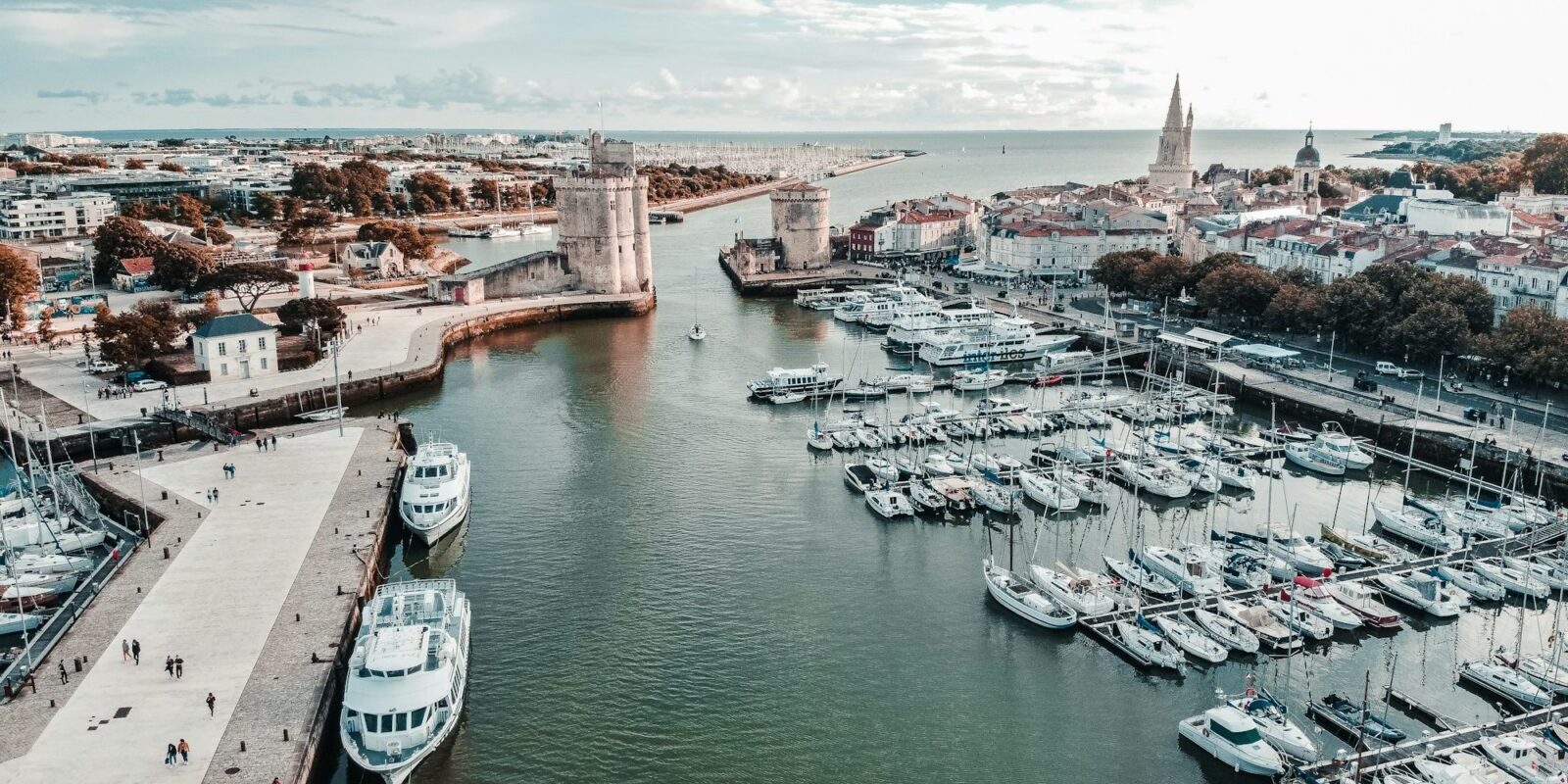
The Vieux-Port is the historic harbour of La Rochelle, its entrance guarded by the two mediaeval towers Saint-Nicolas and de la Chaîne. The outer part, the Havre d'échouage, dries out at low water. Behind it, beyond a gate, lies the Bassin des Yachts, in which the water remains even at low tide. All around begins the old town with restaurants, bars and shops; the harbour office stands on the Quai du Gabut.
Facilities at the Vieux-Port
The Bassin des Yachts has 90 berths on five floating pontoons for boats up to 14 metres in length and with a draught of up to 4 metres. Guest berths are at the Quai d’Honneur. The Havre d’échouage has 120 berths, 20 of them for guests, for boats up to 11 metres in length and with a draught of up to 1 metre. Boats also moor alongside each other there. Electricity and water are available on the quay and at the pontoons, and showers and Wi-Fi at the harbour office. The harbour office is staffed from 6 am to 9 pm in the season and from 8 am to 12 noon and 2 pm to 6 pm outside the season.
Where is the Bassin des Chalutiers?
The Bassin des Chalutiers, the former trawler basin, lies just south of the Vieux-Port between the old town and the railway station. The museum ships of the Musée Maritime also lie here. The basin is protected by a gate like the Bassin des Yachts, over which a bascule bridge runs.
Facilities at the Bassin des Chalutiers
The basin is equipped for large yachts of 17 to 50 metres in length and up to 16 metres in beam; larger vessels can moor here by reservation. At four pontoons, a draught of up to 5 metres is possible. Guests moor at a horseshoe-shaped floating pontoon. Electricity and water are available at the pontoons.
Where is the Port des Minimes?
The Port des Minimes lies in the Les Minimes district southwest of the old town, on the approach to the Vieux-Port. It was built in a former marsh and extends over about 100 hectares in several basins with around 15 kilometres of pontoons. The harbour office stands on the centre pier; next to it are the Plage des Minimes, the university and the breakwater promenade Digue du Nouveau Monde.
Facilities at the Port des Minimes
Of the 5,157 berths on 64 pontoons in the four basins of Bout Blanc, Marillac, Lazaret and Tamaris, 400 are reserved for guests. Electricity and water are available at the pontoons, access to the pontoons is secured with a card, and the harbour is guarded at night. At the fuel pontoon with nine pumps, you can fill up with diesel and Super 98 around the clock using a bank card; from June to August, staff are also on site. Wi-Fi is free for guests, and the login details are on the invoice. For work on your boat, there are three travel lifts of up to 50 tonnes, a mobile crane of 30 tonnes, a slipway and boatyards in the surrounding area.
What is the sailing weather like in La Rochelle?
The wind usually blows from the west to northwest, and the Atlantic swell also comes from there. The islands of Ré and Oléron largely break it, so the water off La Rochelle is calmer than on the open coast. Storms can also come from the southwest, however. Météo-France issues warnings for coastal waters whenever winds of force 7 Beaufort or more are observed or expected.
La Rochelle is a tidal sailing area: at spring tides the range between high and low water is a good five metres, at neaps around two to two and a half metres. In the Pertuis the tidal stream runs at about two knots.
Which destinations lie near La Rochelle?
From La Rochelle you can reach the harbours of the three islands Ré, Aix and Oléron in short day sails, plus Rochefort on the Charente and further north Les Sables-d'Olonne. The distances are rounded over-water distances on the usual course from the Vieux-Port; for precise planning the chart applies. From the Port des Minimes the distance is about one nautical mile shorter.
- Île d'Aix: around 10 nm
- Saint-Martin-de-Ré: around 10 nm
- Saint-Denis-d'Oléron: around 12 nm
- Rochefort: around 21 nm
- Les Sables-d'Olonne: around 35 nm
Saint-Martin-de-Ré lies on the north coast of the Île de Ré, which is connected to the mainland by a bridge roughly three kilometres long. You sail under the bridge into the Pertuis Breton. The citadel and town walls have been part of the UNESCO World Heritage Site "Fortifications of Vauban" since 2008. The harbour has an outer harbour and a basin behind a lock that opens about three hours before until two hours after high water. In strong winds from the northwest or northeast, entering is difficult because swell then runs into the outer harbour.
The small Île d'Aix lies south of La Rochelle off the mouth of the Charente and is car-free; not far from it, Fort Boyard stands in the sea. To the west of it, at the northern tip of the Île d'Oléron, lies Saint-Denis-d'Oléron, a harbour on the largest of the three islands.
To Rochefort you sail past the Île d'Aix up the Charente, best on the rising tide. The marina beside the Corderie Royale is accessible at high water via a gate from April to September.
Les Sables-d'Olonne on the coast of the Vendée you reach in a long day's passage through the Pertuis Breton and past the western tip of the Île de Ré northwards.
What can you do on a harbour day in La Rochelle?
The sights of the old town lie at the Vieux-Port and the Bassin des Chalutiers, the beach at the Port des Minimes.
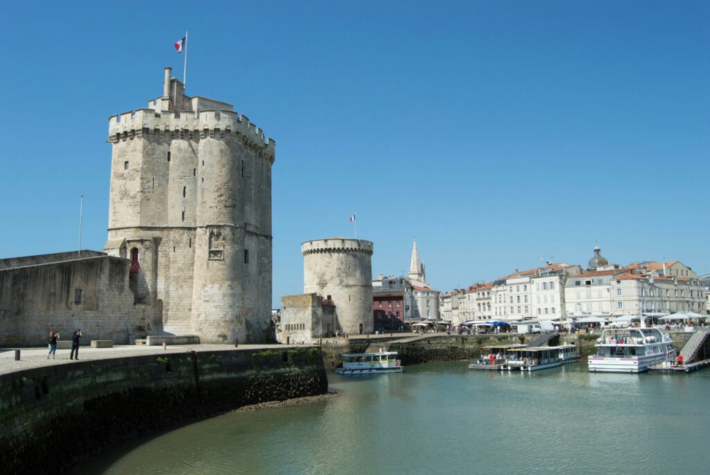
- The towers of La Rochelle: the Tour Saint-Nicolas and Tour de la Chaîne from the 14th century guarded the harbour entrance. The Tour de la Lanterne is considered the oldest lighthouse on the Atlantic coast and also served as a prison for over three centuries; more than 600 prisoners' graffiti are preserved. A combined ticket is valid for all three towers.
- Musée Maritime: in the Bassin des Chalutiers lie the museum ships, including the weather frigate France I and the Joshua, the yacht of round-the-world sailor Bernard Moitessier. The museum is closed on Mondays; allow around two hours for a visit.
- Aquarium La Rochelle: the large aquarium at Quai Louis Prunier displays around 12,000 marine animals from 600 species in 82 tanks. It is open every day of the year, in July and August until 11 p.m.
- Plage des Minimes: the town beach lies directly at the Port des Minimes. From there the Allée des Tamaris runs along the water and a footbridge leads onto the Digue du Nouveau Monde.
For skippers: Berthing and sea weather in La Rochelle
You can reach all three harbours on VHF channel 9, which is staffed around the clock. The call signs are “Capitainerie des Minimes” for Port des Minimes and “Vieux-Port” for the basins in the town. The harbour staff allocate guest berths according to availability: call up on channel 9 or report to the Capitainerie as soon as you arrive, even late in the evening.
Registration and Berthing
At the Port des Minimes, visitors are received around the clock. Yachts over 15 metres in length or with more than two metres draught report to the reception pontoon or the harbour office. At the fuel berth the current sets on the rising tide; berth there with caution.
The mooring fee depends on the length overall and includes water, electricity and sanitary facilities. One night for a monohull yacht of 12 to 12.99 metres costs €52.40 from May to September and €26.20 from October to April. Multihulls pay 1.6 times the price for their length category (as of the 2026 tariff). Anyone who does not register on arrival pays a €50 administration fee.
For Vieux-Port and Bassin des Chalutiers, you report your entry and departure at least one hour in advance on channel 9 or by phone, and for a passage at night by 5 pm the day before. The gate to the Bassin des Yachts is open from two and a half hours before to one hour after high water, and the footbridge above it opens two and a half hours, one and a half hours and half an hour before high water, and one hour after. You can enter the Bassin des Chalutiers from two hours before to one and a half hours after high water; the bascule bridge opens two hours and one hour before high water, at high water, and for the last time one and a half hours afterwards.
Harbour rules
A maximum speed of 3 knots applies in all harbour basins and 5 knots in the approaches. Swimming and bathing are prohibited in the harbour basins. Outside the gate times, the only options are the drying Havre d’échouage or Port des Minimes.
Approach
Coming in from sea, you orient yourself by the Bout-du-Monde lighthouse and the light on the Pointe des Minimes. The approach begins between two lit buoys; the leading line bears 059 degrees to the harbour, with four red buoys kept to port. At the fairway stands the Tour Richelieu with a red light; from about five nautical miles away you can see the towers of the old town. The entrance to the Port des Minimes branches off from this approach; it is navigable by day and night, except at low water at spring tides.
Which sea weather forecast applies in La Rochelle?
The authoritative forecast is the sea weather report from Météo-France. La Rochelle lies in the coastal area "De l'anse de l'Aiguillon à la frontière espagnole"; the coastal report is valid up to 20 nautical miles offshore.
At Port des Minimes, the weather forecast is posted every morning at 8.30 am in the Capitainerie and in the sanitary buildings.
On VHF the rescue coordination centre CROSS Étel broadcasts the weather reports. The nearest station is Chassiron at the northern tip of the Île d'Oléron, which transmits the report on channel 63 in a continuous loop. The transmission times of all stations are listed in the Marine weather guide from Météo-France.
Trips from La Rochelle on Törnfinder
You can find an overview of offers on all French coasts at Sailing in France, all offers at Trips. Further harbours on the French Atlantic coast are featured in the portraits on Port du Crouesty and on Marinas in Brest .
Frequently asked questions
How do I get from La Rochelle Airport to the harbour?
Most convenient by taxi, it's about ten minutes into the town centre. Cheaper options Monday to Saturday are bus route Illico 1b into the centre, and on Sundays line D9; a ticket costs €1.50.
How do I get from the Vieux-Port to the Port des Minimes?
By bus de mer: the boat departs from the foot of the Tour de la Chaîne to pontoon 7 at Port des Minimes and takes about 20 minutes. A single journey costs €3; from October to March the boat only runs at weekends, on public holidays and during school holidays.
Where do I park at the start of my trip in La Rochelle?
In the town centre at the Vieux-Port Sud underground car park, with rates for three and seven days, or at the Encan car park at the Bassin des Chalutiers, or at Port des Minimes on the Quai du Bout Blanc. You can park free at the park-and-ride sites on the edge of town and take the bus into the centre.
Are there showers in the harbours of La Rochelle?
Yes. Port des Minimes has showers in four places, open around the clock and free of charge, as well as a launderette; for Vieux-Port and Bassin des Chalutiers, there are showers in the harbour office on the Quai du Gabut.
When can I enter the Vieux-Port of La Rochelle?
Bassin des Yachts: from two and a half hours before to one hour after high water. Bassin des Chalutiers: from two hours before to one and a half hours after high water. Report your entry and departure at least one hour in advance on VHF channel 9.
What is the tidal range in La Rochelle?
At spring tides a good five metres, at neap tides around two to two and a half metres. In the Pertuis the tidal stream runs at about two knots.
How far is it from La Rochelle to Saint-Martin-de-Ré?
About 10 nautical miles from the Vieux-Port, under the bridge to the Île de Ré and through the Pertuis Breton. The basin at Saint-Martin is only accessible at lock times around high water.