
The Legendary Isle of Skye



 Seehase

This page was translated automatically from German. View the original
Magical Skye
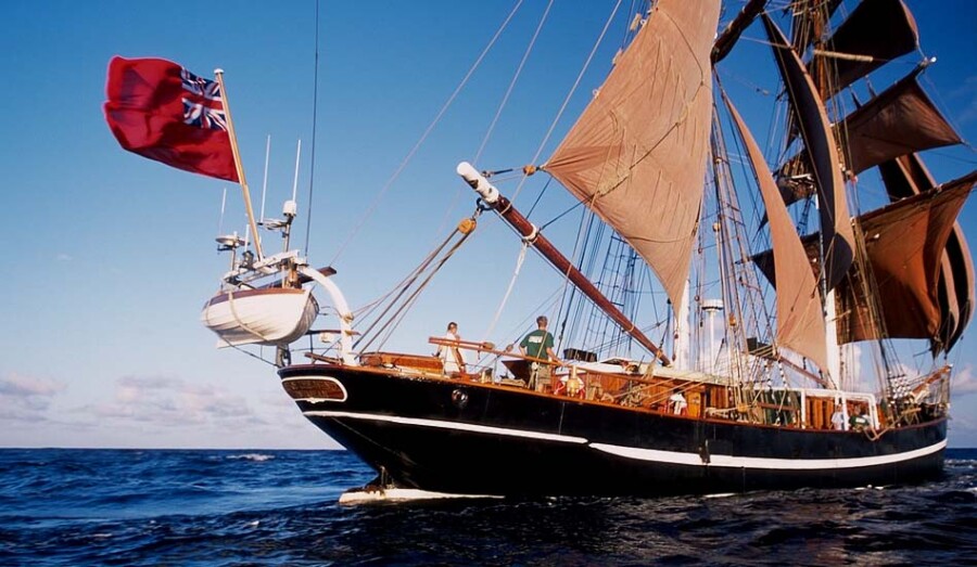
The Isle of Skye is a magical place! Its name comes from “Sküyo”, as the “Cloud Island” was already known in Viking times. With its mountain ranges and kilometres of breathtaking coastline, the island will cast its spell on you again and again. Majestic geological landmarks such as the Old Man of Storr and the Cuillin Hills shape the unique landscape. The island also looks back on a rich cultural history – prehistoric sites and the dark castles of the old clans tell of the past. Skye connoisseurs also appreciate the high-quality malt whisky. We explore this sailing area aboard the Eye of the Wind. It delights everyone who loves Scotland and offers incomparable travel experiences.
During this voyage our ship turns 116 years old: 19 July is the date on which she was first entered in the shipping register. Back in 1911 she still sailed under the name Friedrich. To mark the occasion, the ship's cook will surely conjure up a birthday cake in his galley, so that the historic date can be celebrated properly on board.
Embarkation in the picturesque harbour of Portree takes place at 7 pm. At the shared dinner in the cosy saloon that follows, you will soon feel at home on the deck planks of the Eye of the Wind and get to know your fellow travellers.
Our sailing area: the island world of the Inner Hebrides
Wind and weather permitting, we plan to sail around the northern side of Skye. Our stage destination is the village of Carbost on Loch Harport, which cuts deep into the coastline. Talisker, the only single malt whisky on Skye, has been made there for 190 years. If weather conditions and our progress allow, we plan to include a visit to a whisky distillery on our route. We then continue along the south-western tip of Skye and pass through the channel to the island of Soay.
Loch Scavaig and the Black Cuillin Hills
Past submerged rocks and seal banks, we reach Loch Scavaig, the most beautiful anchorage on this stretch of coast. Footpaths lead into the well-sheltered interior of the island, with views of the rugged basalt rock of the Black Cuillin Hills mountain landscape. A magical spell seems to hang over this remote mountain world, with its intoxicating silence and unspoilt character. From the Isle of Skye we then continue south, passing between the islands of Rum and Eigg.
Tobermory on the Isle of Mull
Another possible destination for the day is Tobermory, the main town of Mull, the third-largest of the Hebridean islands. Right in the north lies one of Scotland's prettiest harbour towns. The waterfront is full of colour, a landmark of the west coast and a picture-postcard idyll of brightly painted houses in a semicircular bay. The attractions of this charming town include not only its many pubs but also the distillery and the Isle of Mull Museum. For over 150 years Tobermory has had the “Mishnish”, a popular sailors' meeting place and “best pub in town”. Our excursion tip: at the northern end of the town, follow the footpaths to the lighthouse at Ardmore Point.
It is 25 nautical miles from Tobermory to Oban, our destination harbour – a pleasant distance to round off the sailing trip. The coastal passage takes us through the Sound of Mull. On the shore of the island of the same name, Duart Castle sits on a steep cliff, and has been the ancestral seat of Clan Maclean for 700 years.
Good reasons to take part in this trip
Under sail through the islands of the Inner Hebrides
Spectacular natural scenery around the Isle of Skye
A well-balanced mix of time at sea and varied excursions ashore
Visit to a whisky distillery (optional / weather permitting)
Traditional ship operations aboard a tall ship more than 100 years old – you can get actively involved!
Excellent galley with delicious meals from morning to evening
Our friendly permanent crew know the route from previous trips and ensure a maritime feel-good atmosphere on board
I'm happy to send further details
Karsten/ marevent.de
Map from OpenStreetMap. When the map is displayed, data is transmitted to the provider.
More InformationMap from OpenStreetMap. When the map is displayed, data is transmitted to the provider.
More InformationBrig
122 feet
