This page was translated automatically from German. View the original
The Port of Nice, usually called Port Lympia locally, lies in the east of the city centre between the Castle Hill and Mont Boron. Here you can read how to get there for your trip departure, where to park and shop, what wind to expect, which sailing destinations on the Côte d'Azur are nearby and what skippers should know about registration, approach and sea weather.
The essentials at a glance
- From the airport, tram line 2 runs from both terminals directly to the Port Lympia stop without changing.
- There is an underground car park with 382 spaces directly at the Bassin Lympia.
- A supermarket is located around 700 metres north of the harbour; fruit, vegetables and fish are available Tuesday to Sunday mornings at the market on Cours Saleya.
- Usually only light breezes blow along the coast. The harbour only becomes uncomfortable in winds from south to south-east; it is sheltered from all other directions.
- Villefranche-sur-Mer is just under 3 nautical miles away, Monaco around 8 nautical miles.
Where is the Port of Nice?
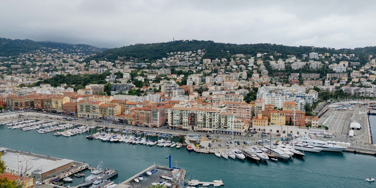
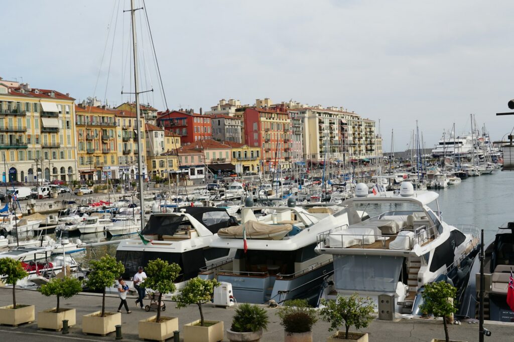
The harbour is built into the town and consists of several basins one behind the other: from the entrance in the south you pass through the outer harbour to the Infernet and des Amiraux basins, past the quay of the commercial port, and right at the inner north end to the Bassin Lympia. Around a hundred Pointus, the colourful traditional fishing boats of the region, also moor there.
Map from OpenStreetMap. When the map is displayed, data is transmitted to the provider.
More InformationTo the west of the harbour rises the Castle Hill, with the old town behind it, and west of that begins the Promenade des Anglais. To the east, Mont Boron rises, behind which opens the roadstead of Villefranche. Buildings with ochre, yellow and red façades stand all around the basins. The harbour belongs to the area that UNESCO inscribed in 2021 as the World Heritage Site "Nice, winter resort town of the Riviera".
Ferries to Corsica and cruise ships use the same harbour as the yachts. It should not be confused with the Port de Saint-Laurent-du-Var around 5 nautical miles further west beyond the airport, which we describe in a separate feature .
Arriving at Nice harbour for the trip start
From Nice Airport to the harbour
The tram is the easiest way. Line 2 runs from Terminal 1 and Terminal 2 via Jean Médecin station in the city centre to Port Lympia stop at the harbour. The journey to Jean Médecin station takes less than 30 minutes, Port Lympia lies a few stops further east. On weekdays the tram runs every 7 to 8 minutes. Only on 1 May does it not operate.
You buy the ticket before the journey. The easiest is the AERO return ticket: the return journey is not tied to any particular day, and you get it from the machines at the two terminal stops. Single journeys (SOLO) and passes for one or more days are also available from the machines and at the travel desk in the terminals. The rechargeable card for a 2-euro deposit is available from all tram machines except at the two terminals.
Taxis wait at Terminal 1 at exit A1 and at Terminal 2 at exit A3. As things stand (November 2026), the taxi fare to the centre of Nice is a flat €32, and the AERO tram ticket costs €10.
By train or ferry
Nice-Ville main station lies on the coastal route Marseille – Toulon – Nice and on the Cannes – Nice – Monaco – Menton line. From the station you walk through the city centre to Jean Médecin station and from there take tram line 2 to Port Lympia.
If you come by ferry from Corsica, you arrive at Nice harbour and are already at your destination.
Parking
The Port Lympia underground car park is right next to Bassin Lympia. It has 382 spaces; the vehicle entrance is on Quai Lunel, and on foot you enter via the Esplanade de la Douane. The entrance has a maximum height of 2.10 metres, so a tall van will not fit. On level −2 there are 40 spaces with charging points for electric cars. As things stand (November 2026), parking costs €2.80 per hour, with the first 15 minutes free. From 12 to 2 pm and from 7 pm to 1 am you pay half price. For a week-long sailing trip there is a flat rate of €130 for 7 days, which you pay in advance at the car park office on level −1.
Showers and sanitary facilities
The showers and toilets in the harbour are accessible around the clock; you can get the badge for them at the harbour office. The laundry with washing machines and dryers is open from 8 am to 6 pm, and the tokens are also available from the harbour office.
Shopping for the trip
The nearest supermarket is a Super U about 700 metres north of the harbour, a short walk with luggage or shopping bags. You buy fresh produce at the market on Cours Saleya in the old town, about 800 metres west of Bassin Lympia as the crow flies, behind the castle hill. Fruit, vegetables and fish are available there Tuesday to Sunday from 6:00 to 13:30. On Mondays a flea market stands on the square instead.
For the big shop by car you drive to the Nice Lingostière shopping centre on Boulevard du Mercantour, about 8 kilometres northwest as the crow flies in the Var valley. The Carrefour hypermarket there opens from 8:00 to 21:00, Sundays from 8:00 to 12:30.
Doctor, pharmacy and emergency services
The nearest pharmacy is the Pharmacie du Port Lympia, about 200 metres southeast of Bassin Lympia at the harbour. About 700 metres west lies the Pharmacie de la Cathédrale in the old town, about 1.2 kilometres north the Pharmacie Sézionale. A medical centre (Centre médical) lies about 700 metres northwest of Bassin Lympia. The adult emergency department at Hôpital Pasteur of the university hospital, 30 Avenue de la Voie Romaine, is open round the clock and lies about 3 kilometres north of the harbour.
- 112: European emergency number
- 15: ambulance service (SAMU), 17: police, 18: fire brigade
- 196: Sea rescue (from land), VHF Channel 16: Distress and calling channel at sea
What does Nice harbour offer?
The harbour has nearly 500 berths, about 100 of them reserved for visitors. It takes yachts up to 180 metres in length, the water depth lies between 4.5 and 8 metres depending on the basin. You make fast to moorings, to floating pontoons or at the fixed quays for large yachts.
| Feature | Details |
|---|---|
| Location | East of the city centre, between the castle hill and Mont Boron |
| Harbour office | 2 Quai d’Entrecasteaux, 06300 Nice, Tel. +33 4 92 00 42 14 |
| Operator | Métropole Nice Côte d’Azur |
| Website | leportdenice.com |
| Fuel station | Tel. +33 4 92 00 43 88 |
| VHF channel | 9 |
| Capitainerie opening hours | from April daily 7 am–8 pm, from July daily 7 am–9 pm, from September daily 7 am–8 pm, from November Mon–Sat 7 am–6 pm (as of November 2026) |
| Berths | 488, of which about 100 for visitors |
| Distance | Yachts up to 180 m |
| Water depth | Outer harbour 8 m, Bassin Infernet 7.1 m, commercial harbour quay 6.8 m, Bassin des Amiraux 6.5 m, Bassin Lympia 4.5 m |
| Entrance (outer breakwater light) | 43° 41,4′ N, 007° 17,3′ E |
Equipment
Water is available at all berths. Electricity is available at the pontoons at 16 amperes, at the berths for large yachts up to 600 amperes. In the harbour there is a fuel station where you refuel round the clock by card, a 20-tonne crane, a slipway and a place for underwater hull work. In addition there is free Wi-Fi and a waste oil collection point. Pets are allowed.
Mooring fees
Visitor berths for boats up to 18 metres are priced by berth category, based on length and beam. Water and electricity up to 16 amps are included in the price. Under the 2026 tariff (as of November 2026), a berth for a yacht up to 11.99 metres in length and 4 metres in beam costs €41.96 per day in the season from 1 May to 1 October, and €20.98 per day outside the season. For up to 13.99 metres in length and 4.60 metres in beam, it is €56.30 and €28.15 per day. A preferential rate applies from 30 days, and multihulls are charged according to their surface area.
What is the weather like in Nice for sailing?
Off Nice the wind is light most of the time. In summer a breeze comes from seaward during the day, at night it blows weakly from the land. Météo-France warns for the coast from force 7 of strong wind and from force 8 of near gale.
From late autumn to spring, the most frequent wind is the Levant from the east, moderate to strong, very humid and usually with thick cloud and rain. The Marin from the southeast comes mainly in spring and autumn, usually blows strongly and steadily, and often brings heavy rain. The Grégale can blow from the northeast, and the Libeccio from the southwest, which is warm and dry on the Côte d’Azur.
Wind from south to southeast stands directly onto the harbour entrance, against all other directions you lie sheltered in the harbour.
You hardly notice tides in the harbour. With low air pressure and strong wind from seaward the water stands a little higher.
Which trip destinations lie near Nice?
To the east lie the roadstead of Villefranche, Beaulieu and Monaco close together, to the west you reach Antibes beyond the airport and the Îles de Lérins off Cannes. The distances given are rounded distances over water on the usual course from the harbour; the sea chart applies for exact planning.
- Villefranche-sur-Mer roadstead: just under 3 nm, right behind Mont Boron
- Beaulieu-sur-Mer: around 5 nm, outside around Cap Ferrat
- Monaco: around 8 nm, around Cap Ferrat and Cap d'Ail
- Antibes: around 9 nm, outside past the airport
- Îles de Lérins: around 16 nm, around Cap d'Antibes
- Cannes: around 17 nm, north past Île Sainte-Marguerite
- Calvi on Corsica: a good 90 nm across open water
The Villefranche roadstead is so close it makes a good anchorage for the first afternoon after provisioning. The Préfecture maritime has established zones with anchoring prohibited there and a maximum speed of 5 knots in the northern part of the roadstead. Beaulieu lies on the east side of the Cap Ferrat peninsula, Monaco is a classic destination for a day's sail. Antibes is a short hop westward, the Îles de Lérins are a full day's sail.
On your way west you pass the airport. There the Préfecture maritime has established restricted zones, graded by height above the waterline: directly off the airport grounds, yellow buoys mark an area where navigation and anchoring are prohibited. Surrounding it are zones closed to vessels with a height of 3 metres and 10 metres or more above water, extending as far as the Baie des Anges. The exact boundaries are given in the Decree of the Préfecture maritime.
For Corsica, with a good 90 nautical miles to Calvi, you'll need an overnight passage or a very long day. We feature a harbour on the island in the profile of the harbours of Bastia .
What can you do on a harbour day in Nice?
The old town, castle hill and the Promenade des Anglais are all within walking distance from the harbour, you won't need a car for a harbour day.
- Pointus in the Bassin Lympia: At berth M right at the head of the basin lie around a hundred of these traditional fishing boats. Walking along the harbour gives you a glimpse of old Nice.
- Castle hill: The park on the Colline du Château between harbour and old town is open daily and free to enter. From the top you can see across the Baie des Anges, the old town and the harbour, whilst beside you an artificial waterfall from 1885 cascades down the hillside.
- Old town and Cours Saleya: The market in the old town is liveliest in the mornings, on Mondays the square belongs to the flea market traders.
- Promenade des Anglais: West of the old town begins the seafront promenade, which together with the harbour, castle hill and Quai des États-Unis is a World Heritage Site.
For skippers: Berthing and sea weather in Nice
Before entering the harbour of Nice, ask the capitainerie on VHF channel 9 for a free visitor's berth.
Registration and Berthing
The Capitainerie can be reached on VHF channel 9 under the call sign “Nice Plaisance” and by phone on +33 4 92 00 42 14. As things stand (November 2026), it is staffed daily from 7:00 to 20:00 from April, until 21:00 from July, again until 20:00 from September, and Monday to Saturday from 7:00 to 18:00 from November. Channel 16 is the distress and calling channel, not the harbour's channel. You can reserve a visitor berth online: on the harbour website you create a customer account and submit a berth request through it. The harbour staff will help you with mooring, casting off and connecting to shore power, daily from 8:00 to 20:00.
Harbour rules
- Visitor berths are allocated for 24 or 72 hours, depending on availability. In high season it is worth reserving through the customer account on the harbour's website. You are charged per day or part thereof, counted from noon to noon.
- Since 1 June 2026, two protected zones extend up to 300 metres offshore: off the Promenade des Anglais, along about 740 metres between the Centre universitaire méditerranéen and the Hotel Negresco, you may neither anchor nor stop nor pass through. At Pointe des Sans-Culottes east of Cap de Nice, anchoring is prohibited along about one kilometre of coast. The aim is to protect seagrass meadows and coral reefs there.
- Commercial shipping has priority. Which quays are reserved for cruise ships and cargo vessels the following day is shown on a board at the capitainerie each evening.
Approach
The entrance lies at approximately 43° 41.4′ N, 007° 17.3′ E at the head of the large outer breakwater. By day, steer a course of 012° towards the observatory on Mont Gros until you reach the light at the end of the breakwater. Then round the breakwater head and leave the short Poudrière breakwater to starboard. At night, first follow the white light of Cap Ferrat, then the red light at the head of the outer breakwater; the Poudrière breakwater carries a green light.
Watch out especially for ferries and cruise ships. An outbound vessel won't be visible until it emerges from behind the breakwater. At several points in the harbour, including the outer breakwater and the Quai Infernet, traffic lights control movements, and they apply to yachts as well. Off the coast, you must not exceed 5 knots in the 300-metre-wide coastal strip, as laid down by the Préfecture maritime de la Méditerranée for the entire French Mediterranean coast.
Which sea weather forecast applies to Nice?
The relevant forecast is the coastal weather report from Météo-France for the area "Côte d'Azur, from Saint-Raphaël to Menton". The rescue coordination centre CROSS La Garde broadcasts it on VHF and announces each transmission in advance on channel 16. Warnings of 7 Beaufort or more are also broadcast outside the scheduled times.
For a passage to Corsica you'll also need the offshore forecast. On NAVTEX, the station La Garde transmits with identifier W on 518 kHz reports in English, including for the areas Ligure and Corse. All broadcast methods are explained in the Marine weather guide from Météo-France.
Trips from Nice on Törnfinder
In November 2026 there are 5 trip dates on Törnfinder from 2 providers with departure or destination in the harbour of Nice.
All current offers are in the trip overview. An overview of the whole country is given on the page Sailing in France; trips in the wider region can be found under Sailing in the Mediterranean.
Frequently asked questions
How do I get from Nice airport to the harbour?
Tram line 2 from Terminal 1 or 2 direct to Port Lympia stop. Taxis to the city centre are available at Terminal 1 exit A1 and Terminal 2 exit A3 and charge a flat rate.
Where do I park at the start of my trip in the port of Nice?
In the Port Lympia underground car park directly at the Bassin Lympia, with 382 spaces and access via Quai Lunel. Maximum entrance height is 2.10 metres.
Are there showers in the port of Nice?
Yes, the showers and toilets are accessible around the clock, and you can pick up the badge at the harbour office. There is also a laundry.
Where can I shop near the port for the trip?
At Super U about 700 metres north of the port. Fresh produce is available Tuesday to Sunday mornings at the market on Cours Saleya in the old town.
Are Port Lympia and the port of Nice the same thing?
Yes. Port Lympia is the common name for the port of Nice, named after its innermost basin, the Bassin Lympia. Port de Saint-Laurent-du-Var is a different harbour west of the airport.
Which VHF channel can I reach the port of Nice on?
On channel 9, call sign "Nice Plaisance". Call them before entering to ask for an available berth.