This page was translated automatically from German. View the original
The Vieux-Port in Marseille is the old harbour in the heart of the city; around six kilometres further south lies Pointe Rouge harbour. Here you can read how to reach the Vieux-Port and Pointe Rouge for your trip start, where you park and shop, what weather to expect, which sailing destinations lie close by from the Frioul to the calanques, and how skippers moor there.
The essentials at a glance
- From Marseille Provence airport the airport bus runs in 30 to 50 minutes to Saint-Charles station; from there it's two metro stops to the Vieux-Port.
- To reach Pointe Rouge, take bus 19 from the metro stations Castellane or Rond-Point du Prado; from the end of April to the end of September there is also a ferry service from the Vieux-Port.
- Around the Vieux-Port there are several public car parks. A low-emission zone applies to the city centre.
- You can do your initial shopping on foot at the Vieux-Port; for the main shop, drive by car to the edge of town.
- The mistral blows all year round, more strongly in winter and spring, and brings cool air. A warm layer belongs in your luggage even in summer.
Where is the Vieux-Port in Marseille?
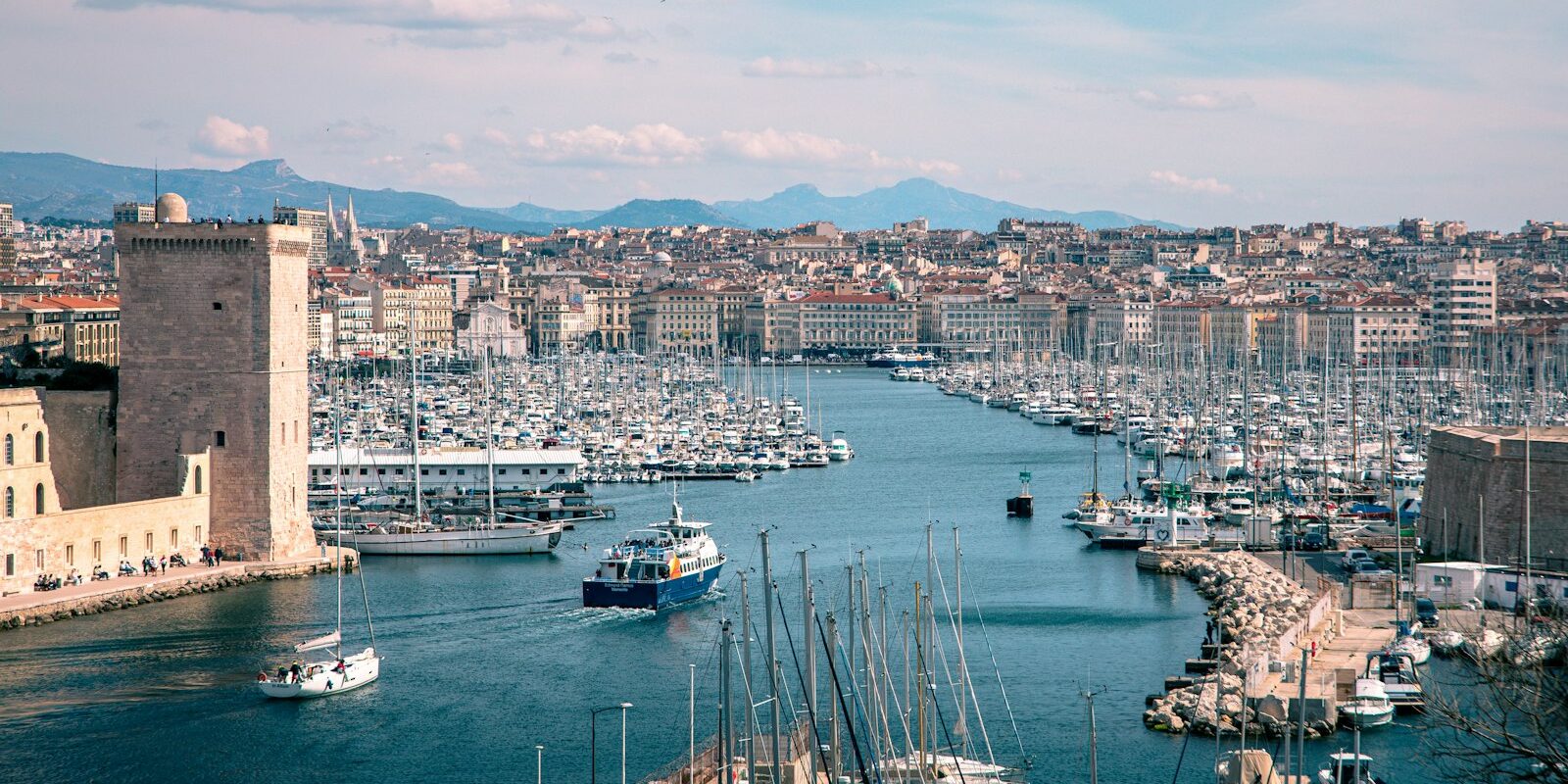
The Vieux-Port is a long harbour basin which extends from the entrance between Forts Saint-Jean and Saint-Nicolas eastwards as far as the Quai des Belges in the city centre. Pointe Rouge lies in the south of the city in the 8th arrondissement by a beach. Both harbours are operated by Métropole Aix-Marseille-Provence.
Map from OpenStreetMap. When the map is displayed, data is transmitted to the provider.
More Information| Feature | Vieux-Port | Pointe Rouge |
|---|---|---|
| Location | City centre, entrance in the west, basin extends to Quai des Belges | South of the city (8th arrondissement), around 6 km as the crow flies from the Vieux-Port |
| Berths | around 3,200 | 1.480 |
| Boat length | up to 70 m | up to 15 m |
| Water depth | 5–7 m in outer harbour and basin | 3–7 m in basin |
| Mooring | on floating pontoons | on mooring lines |
| Harbour telephone | +33 4 91 99 75 60 | +33 4 91 99 75 67 |
| hoist and crane | 20 t, cranes 6 t | 30 t, cranes 1.5 t |
Electricity, water, sanitary facilities and ice are available in both harbours.
Arriving for your trip start in Marseille
The hub for arrivals is Saint-Charles station: the airport bus and long-distance trains arrive here, and the metro continues from here.
From Marseille Provence airport to the Vieux-Port
The airport is at Marignane, 27 kilometres from the city centre. The airport bus runs daily from about 4 a.m. until after midnight direct to the bus station at Saint-Charles station, during peak times roughly every ten minutes. The stop is between the terminals. Depending on traffic, the journey takes 30 to 50 minutes.
From Saint-Charles, metro line M1 runs in two stops to the Vieux-Port station; on foot you walk down the large staircase in front of the station to the harbour in about 20 minutes. The metro runs roughly from 5 a.m. to midnight every 5 to 15 minutes; you can pay for your ticket at the stations contactless with your bank card as well. The alternative to the airport bus: take the bus from stand 5 in about five minutes to Vitrolles station, then the regional train (TER) in about 20 minutes to Saint-Charles.
Taxis wait round the clock outside Terminal 1 and will take you directly to the quay.
To Pointe Rouge, from Saint-Charles take metro line M2 to Rond-Point du Prado and there change to bus 19 towards Madrague de Montredon, stop Pointe Rouge. Bus 19 also stops at Castellane metro station, where M1 and M2 stop.
By car, train, bus or ferry
Long-distance trains stop at Saint-Charles station in the city centre. By car you can reach Marseille via the A7, which ends near Saint-Charles station, the A55 from the direction of Martigues or the A50 from the direction of Toulon. The tolled Prado-Carénage tunnel connects the A50 and A55 and has an exit at the Vieux-Port.
A low-emission zone (ZFE-m) has been in force for the city centre since September 2022. Check whether your car is permitted to enter on the Métropole Aix-Marseille-Provence.
Ferries from Corsica, Sardinia and North Africa arrive at the ferry terminal at Place de la Joliette. From there it's about a 20-minute walk to the Vieux-Port, or by metro take the M2 to Saint-Charles and change to the M1.
Which harbour is mine?
If you're arriving for a cabin charter: the harbour and which pontoon is stated in your trip documentation. The crucial thing is the name of the harbour, as Vieux-Port and Pointe Rouge are in different parts of the city.
In the Vieux-Port the quay name will help you. On the south side are the Quai Marcel Pagnol with the harbour master's office and the Quai de Rive Neuve; on the north side is the Quai du Port, and at the eastern end the Quai des Belges. If you're on the wrong side, the Ferry Boat will take you across the basin in three to four minutes.
Parking
There are several public car parks around the Vieux-Port, including at Place aux Huiles near the Quai de Rive Neuve, at 38 Quai de Rive Neuve and on the Esplanade J4 by the Mucem. At some you can reserve a space for several days in advance via an app.
If you're just dropping off crew and luggage by car, drive right up to the quay to unload.
Arrived early: luggage and the old town
If you arrive long before boarding, you can leave your luggage in the lockers at Saint-Charles station on level -1. They are accessible daily from 08:15 to 21:00, including public holidays. The best way to spend the waiting time is at the Vieux-Port and in the old quarter of Le Panier just behind it.
Facilities
The Vieux-Port and Pointe Rouge have toilet and shower facilities.
Shopping for the trip
A large supermarket within walking distance is the Monoprix at 36 Canebière, a good 400 metres from the eastern end of the Vieux-Port. From the Quai Marcel Pagnol it's about a quarter of an hour on foot. It's open daily, with shorter hours on Sundays.
For a big shop it's worth taking the car. The hypermarket in the Grand Littoral shopping centre in the 15th arrondissement is about 9 kilometres away to the north and is open Monday to Saturday from 08:00 to 21:00, closed Sundays. If you're berthed at Pointe Rouge, there's a Carrefour supermarket on Avenue de Hambourg in Bonneveine about 2 kilometres away.
Doctor, pharmacy and emergency services
The adult A&E in the city centre is at Hôpital de la Timone, 264 Rue Saint-Pierre, about 2.5 kilometres east of the Vieux-Port. For a pharmacy on night, Sunday or public holiday duty, call the national number 3237.
- 112: European emergency number
- 15: ambulance service (SAMU), 17: police, 18: fire brigade
- 196: Sea rescue by telephone from the coast; at sea use VHF channel 16 first
What does the Vieux-Port offer?
Greek seafarers from Phocaea founded the city in the Vieux-Port around 2,600 years ago; the bay was then called Lacydon. Today it's home to leisure craft, excursion boats and fishing boats.
Part of the pontoons are managed by two sailing clubs on behalf of the Métropole: the Cercle Nautique et Touristique du Lacydon (CNTL) on the Quai Marcel Pagnol and the Société Nautique de Marseille on the Quai de Rive Neuve. There's also a chandlery at the harbour.
When is Pointe Rouge the better choice?
Pointe Rouge is suitable if you want to berth a boat up to 15 metres away from the city bustle, refuel or get to the Calanques more quickly. The harbour is about 4 nautical miles from the Vieux-Port over water, right on the city's largest sandy beach.
With 1,480 berths, Pointe Rouge is one of the city's major harbours after the Vieux-Port. There's a fuel station with card payment at the harbour entrance, a 30-tonne lift for work ashore and two slipways. Restaurants and beach bars surround the harbour. In season the shuttle boat (Navette) gets you to the Vieux-Port in about 35 minutes.
What weather can you expect off Marseille?
The best-known strong wind off Marseille is the Mistral. It blows from the northwest in the Marseille area throughout the year, but more strongly in winter and spring, and often lasts for several days. It brings dry, cool air and clears away haze and cloud.
In the Vieux-Port basin you're sheltered, but out in the bay and on the way to the Calanques it can become uncomfortable in the Mistral. For those joining a trip this means: even on sunny days it can get cold on the water, so a warm layer and a windproof jacket belong in your luggage. If the Mistral is blowing strongly, the skipper decides whether you put to sea, and a day may become a harbour day. You can read more about the Mistral and other wind systems in the article about Good months for a trip through the region are April, May, September and October. The weather is mild, it's less crowded ashore and the midsummer heat is absent. You can read how the winds in Greece work in our article about.
Where can you go from Marseille?
On the doorstep are the Frioul Islands, to the south the Calanques with their steep rocky inlets, and to the west the Côte Bleue. The distances are rounded sea routes on the usual course from the Vieux-Port; for precise planning use the chart.
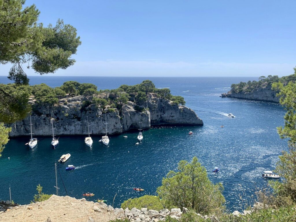
Frioul and Château d'If
The Frioul Islands lie about 3 nautical miles off the Vieux-Port; their island harbour between Ratonneau and Pomègues has berths for visitors and a fuel station. The small island with the Château d'If lies about 2 nautical miles away on the way there.
Calanques
South of the city begins the Calanques National Park, which also includes the Frioul Islands. The island of Riou is about 8 nautical miles away, the Calanque de Sormiou about 10 and the Calanque de Morgiou about 11 nautical miles. To Cassis it is about 16 nautical miles.
Côte Bleue and L'Estaque
L'Estaque in the north of the city you can reach in about 5 nautical miles, round the outside of the long breakwater of the commercial port. The harbour basin there is only a good 2 metres deep and so suits boats with shallow draught up to 20 metres in length. Further west follows the Côte Bleue; to Carry-le-Rouet it is about 10 nautical miles. Those on a longer passage can also cross from Marseille to Corsica.
What can you do ashore in Marseille?
From the Vieux-Port you can reach the city's best-known attractions on foot or with a short journey. The distances are as the crow flies from the eastern end of the harbour.
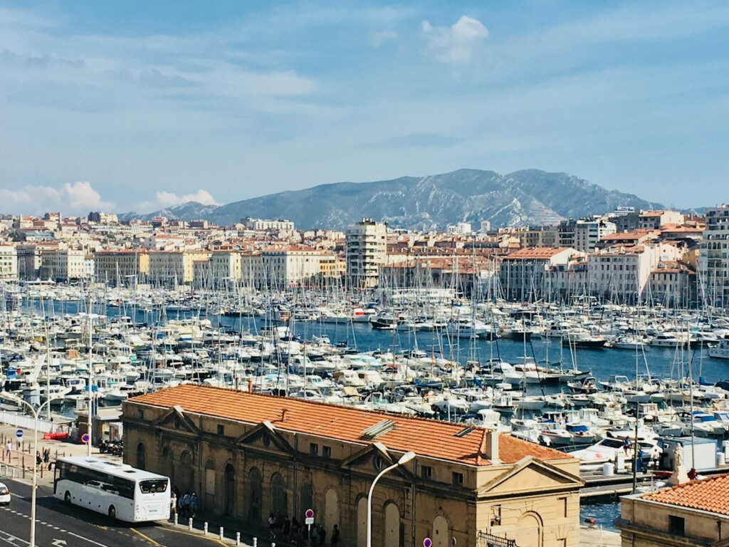
- Fort Saint-Jean and Mucem: The Museum of European and Mediterranean Civilisations has stood on the J4 jetty at the harbour entrance since 2013, about a kilometre away. A high footbridge connects it to Fort Saint-Jean, through whose garden you can stroll free of charge. Closed Tuesdays.
- Le Panier: The old quarter sits on a hill directly behind the Quai du Port. Narrow lanes lead you to the Place de Lenche, the Montée des Accoules and the Vieille Charité.
- Notre-Dame de la Garde: The basilica stands about 1.2 kilometres to the south on a hill just under 150 metres high. The large statue of the Virgin Mary on the tower was completed in 1869. Bus 60 runs up there from the Vieux-Port.
- Ferry Boat: The little ferry has crossed the harbour over 283 metres since 1880, daily from 07:30 to 20:30.
- Château d'If: The island fortress dates back to King Francis I; later it was a prison and the setting in the novel "The Count of Monte Cristo". Without your own boat you can take the scheduled ferry from the Vieux-Port; the château is closed on Mondays.
Timetables for the Navettes to Pointe Rouge and L'Estaque can be found at the Marseille Tourist Office.
For skippers: Berthing, sailing area regulations and weather forecasts in Marseille
In the Vieux-Port you register at the Capitainerie des Vieux-Port; at Pointe Rouge with the harbour office Pointe Rouge. Visitor berths at the Vieux-Port are limited relative to the size of the harbour.
Registration at the Vieux-Port
The Capitainerie of the Vieux-Port allocates visitors' berths at Quai Marcel Pagnol. It is located directly behind the entrance on the starboard side, just past the Palais du Pharo, where reception for visiting yachts is also situated. Announce your arrival in advance by telephone on +33 4 91 99 75 60 or on VHF channel 9. The pontoons of the two sailing clubs are mainly occupied by permanent berth holders, with only a few visitors' berths available there.
Berthing in the Vieux-Port and at Pointe Rouge
In the Vieux-Port you berth alongside floating pontoons. Prepare mooring lines and fenders on both sides before entering.
At Pointe Rouge you moor to laid moorings. These are lines attached to a block on the seabed. You pick them up at the pontoon with a boat hook and make them fast at the bow, whilst the stern is secured with your own lines to the pontoon. Your berth will be allocated by the Pointe Rouge harbour office.
Entering the Vieux-Port
The entrance, the Grande Passe, is passable in all weathers; you enter on an easterly course. On the north shore stands the Fort Saint-Jean, on the south shore the Fort Saint-Nicolas, and further west the Palais du Pharo on its headland.
The basin is very busy. Excursion boats and the Navettes, the scheduled ferries to Frioul, Pointe Rouge and L'Estaque, operate all day during the season. In addition, the ferry boat crosses the basin every ten minutes. Proceed slowly and keep clear of these vessels.
Harbour rules
- The harbour regulations prohibit swimming and diving in the harbour basins.
- On public holidays, such as Bastille Day on 14 July or during firework displays, the Métropole closes the Vieux-Port completely to shipping, usually from midday until after the fireworks. The dates are announced in advance.
- At Pointe Rouge you are not permitted to step onto the breakwaters in the area for dinghies and small sailing boats.
Regulations in the Calanques National Park
Within 300 metres of the coast your speed is limited to 5 knots. You may not make fast to yellow buoys that mark boundaries. In some zones anchoring or navigation is completely prohibited; the park chart shows the boundaries. White buoys are ecological moorings where divers have priority.
Which marine weather forecast applies in Marseille?
For Marseille the coastal weather forecast from Météo-France applies for the area "Provence, from Port-Camargue to Saint-Raphaël". The maritime rescue coordination centre CROSS La Garde broadcasts it on VHF, and each broadcast is announced beforehand on channel 16.
For the Bay of Marseille, the relay station Planier transmits on VHF channel 80 at 07:33, 13:33 and 19:33 French time. If winds reach force 7 Beaufort or more, Météo-France issues a gale warning which CROSS La Garde repeats every hour. Navtex broadcasts the forecast in English from station La Garde, call sign W, on 518 kHz (as of October 2026). Strong winds in the Mediterranean often give little advance warning, so checking the forecast is essential before every passage. All broadcast channels are explained in the Marine weather guide from Météo-France.
Sailing trips from Marseille on Törnfinder
In October 2026 there are 34 trip dates on Törnfinder in the next twelve months departing from or arriving at the Vieux-Port Marseille. Most depart in July, June and May, typically with eight days on board, and the trips are offered by two providers. Those wishing to cross from Marseille to Corsica will find trips to that destination at Cabin Charter in Corsica. Offers throughout the country can be found at Sailing in FranceMany sailing trips depart from Trogir: seven charter companies alone have their base at SCT Marina, and there are also charter agencies at ACI Marina. An overview of offers throughout the country can be found on Törnfinder under Sailing in the Mediterranean.
Frequently asked questions
How do I get from Marseille airport to the Vieux-Port?
By airport shuttle bus in 30 to 50 minutes to Saint-Charles station, then by metro M1 two stops to Vieux-Port, or on foot in about 20 minutes. By taxi you travel directly to the quay.
Where do I park when starting a trip at the Vieux-Port?
In one of the public car parks around the harbour, for example at Place aux Huiles, at Quai de Rive Neuve or near the Mucem. A low-emission zone applies to the city centre.
Are there sanitary facilities at the Vieux-Port and Pointe Rouge?
Yes, both harbours have sanitary facilities.
How do I get from the Vieux-Port to Pointe Rouge?
From the end of April to the end of September by scheduled ferry in around 35 minutes. Otherwise, take the metro to Castellane or Rond-Point du Prado and change to bus 19 to the Pointe Rouge stop.
Where do visiting yachts register in the Vieux-Port?
At the Capitainerie du Vieux-Port on Quai Marcel Pagnol, just inside the entrance on the starboard side. Announce your arrival beforehand on VHF channel 9 or by calling +33 4 91 99 75 60, as guest berths are scarce.
Can you refuel in Marseille?
At Pointe Rouge there is a fuel station with a card-operated pump at the harbour entrance.
How far is it from the Vieux-Port to the Calanques?
The Calanque de Sormiou lies about 10 nautical miles away by water, Cassis about 16. In the national park, a speed limit of 5 knots applies near the coast.