This page was translated automatically from German. View the original
Camaret-sur-Mer lies at the western tip of the Crozon peninsula in Finistère, in the heart of the Iroise and halfway between the Chenal du Four and the Raz de Sein. Here you can read how to get to the start of your sailing trip, where the harbours are, where to park and shop, what wind and tidal streams to expect, which sailing destinations are nearby and what skippers should know about registration, approach and marine weather.
The essentials at a glance
- Following Storm Austen, the harbour is, as things currently stand (November 2026), closed to visiting boats until further notice, and that includes the visitor buoys.
- In normal operation, visitors berth in Bassin du Notic directly in front of the town centre or in Bassin Vauban at the Sillon, the shingle bank with the Tour Vauban.
- Bus line 934 links the bus station at Brest railway station with the Camaret Port stop, while line 937 runs to Quimper.
- The nearest supermarket is around 600 metres from Bassin du Notic, and there is a market every Tuesday all year round.
- The wind blows most often from the west and southwest. Around Ouessant, Molène and Sein run the strongest tidal streams in the Iroise.
Where are the harbours of Camaret-sur-Mer?
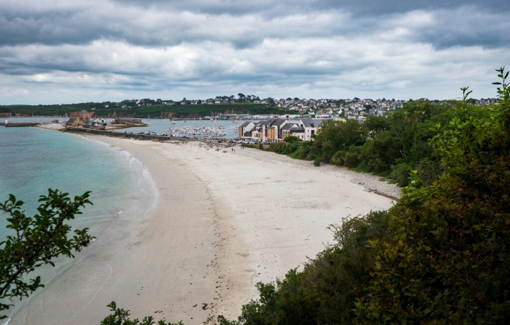
The harbour of Camaret-sur-Mer lies in a sheltered bay directly in front of the town and has two areas for visitors: Bassin du Notic, right in front of the quays in the town centre, and Bassin Vauban, around 500 metres further east at the Sillon, a long shingle bank topped by a granite wall. The Tour Vauban stands at the end of the Sillon. Between the two lies Bassin du Styvel, which is reserved for annual berth holders only.
Map from OpenStreetMap. When the map is displayed, data is transmitted to the provider.
More InformationThe harbour is sheltered by the cliffs of Pointe du Grand Gouin and by the Sillon. It has around 450 berths for annual berth holders and an additional 150 for visitors. It is run by the municipality of Camaret-sur-Mer. The Breton name of the town, Kameled, means “curved harbour”, and that is exactly how the bay looks from the road above the town.
Is the harbour of Camaret-sur-Mer currently open to visitors?
No. After Storm Austen, the entire harbour of Camaret-sur-Mer, including the heavy floating pontoon at the Bassin Vauban, is closed to visiting boats until further notice, as are the visitor buoys outside the harbour (as of November 2026). There is not yet a date for reopening. The municipality publishes the current status on its harbour page.
Regardless of this, the heavy floating pontoon at the Bassin Vauban is closed every winter from the end of October to mid-April.
Arriving for the start of your sailing trip in Camaret-sur-Mer
From Brest airport to Camaret-sur-Mer
The nearest airport is Brest Bretagne. From the airport, bus line 20 runs to Porte de Gouesnou, where you change to tram line A to the Liberté stop in the centre of Brest. From there it is about 600 metres on foot to the station. One ticket is valid for one hour across the whole city network. At quieter times of day, for the last bus in the evening and on some weekend journeys, you need to book the bus by phone in advance.
Bus line 934 to Camaret-sur-Mer starts at the bus station next to Brest station. It runs via Le Faou, Crozon, Morgat and Roscanvel to the Camaret Port stop.
By car, train, bus or ferry
By train you travel to Brest or Quimper. From Brest, line 934 takes you to Camaret-sur-Mer; from Quimper, line 937.
By car, it is about 60 kilometres or an hour's drive from Brest to Crozon, the main town of the peninsula. Camaret-sur-Mer lies to the west of it at the tip of the peninsula. A ferry also connects the commercial port of Brest across the roads with the harbour of Le Fret on the Crozon peninsula.
Parking
Car parks are about 200 metres from the Bassin du Notic on Rue de l’Abri du Marin, and about 250 metres away on Quai Gustave Toudouze and Quai du Styvel. There are separate car parks for harbour users. You can only park there with a parking permit displayed behind the windscreen, which is available from the Capitainerie.
The Sillon leading to the Bassin Vauban and the Tour Vauban is closed to cars and is open only to harbour users.
Showers and sanitary facilities
There are showers in the harbour, and they are included in the berthing fee. You get the access codes from the Capitainerie. There is also a launderette at the Bassin du Notic, and the Wi-Fi for guests is free of charge.
Shopping for the trip
The nearest supermarket is a U Express, about 600 metres from the Bassin du Notic. There are also shops around the Bassin du Notic. Larger supermarkets can be found in Crozon, about 10 kilometres away.
A small market is held on Place Charles de Gaulle every Tuesday all year round. In July and August it takes place on Tuesdays from 9 am to 12:30 pm on the square in front of the town hall and on Place Saint-Thomas.
Doctor, pharmacy and emergency services
The Pharmacie Le Roux is on Quai Gustave Toudouze, about 350 metres from the Bassin du Notic. You can find out which pharmacy is on emergency duty by calling 3237. Several doctors practise in the town, and the nearest hospital is the Centre hospitalier de Crozon, about 9 kilometres away. These emergency numbers apply in France:
- 112: European emergency number
- 15: Emergency medical services (SAMU)
- 17: Police and Gendarmerie
- 18: Fire brigade
- 196: Sea rescue via the CROSS Corsen rescue coordination centre, also by phone on +33 2 98 89 61 55
- At sea: VHF channel 16, and channel 70 for digital selective calling
Camaret-sur-Mer is also home to a lifeboat of the French sea rescue service SNSM; the station has existed since 1867.
Where is the Bassin du Notic?
The Bassin du Notic is the harbour in the middle of the town. The pontoons lie right in front of the quays with their shops. Visitors moor on the outer sides of pontoons A and E, which are the first finger pontoons at the entrance to the basin, and at the berths opposite Quai Toudouze. Together they offer room for about 40 boats.
Nearby is also the Capitainerie du Notic in the town centre, the point of contact for visitors all year round.
Facilities at the Bassin du Notic
Water and electricity at 220 and 380 volts are available on all pontoons. The launderette and the Capitainerie are located at the Bassin du Notic. You can get diesel around the clock using a card at the fuel station in the fishing harbour, which is run by the Coopérative maritime, the fishing harbour cooperative. The boatyard, sailmaker and chandler are on Quai Téphany. There is also a mobile crane there for 10 tonnes and boats up to 3.60 metres in beam, as well as a wash-down area for the underwater hull and spaces for winter storage ashore.
Where is the Bassin Vauban?
The Bassin Vauban, also called Port de la Pointe, lies on the Sillon about 500 metres east of the Bassin du Notic. Yachts with a deeper draught can also find a berth here. Visitors moor at pontoons 2 to 5. Larger vessels moor at the heavy floating pontoon, which also serves as a breakwater, once the Capitainerie has given its approval.
The Capitainerie Vauban on the Sillon is staffed only from June to September. As things stand (November 2026), it will not reopen until June 2027; until then, you check in at the Capitainerie du Notic.
Facilities at the Bassin Vauban
Water and electricity are also available at the Bassin Vauban and at the heavy floating pontoon. In July and August, the Capitainerie Vauban lends out bicycles for short periods.
Camaret-sur-Mer harbour at a glance
| Feature | Details |
|---|---|
| Location | Western tip of the Crozon peninsula, Finistère, Iroise |
| Operator | Municipality of Camaret-sur-Mer |
| Berths | around 450 for annual berth holders, plus 150 for visitors |
| Visitor berths | Bassin du Notic (pontoons A and E, outer sides), Bassin Vauban (pontoons 2 to 5), visitor buoys from 15 May to 15 October |
| Capitainerie du Notic | year-round, Tuesday to Saturday, 9 am to 12 noon and 1.30 pm to 5.30 pm, +33 2 98 27 89 31, capitainerie@camaretsurmer.fr |
| VHF | Channel 9 |
| Electricity and water | at all pontoons, 220 and 380 volts |
| Fuel | Diesel at the fishing harbour, available around the clock with a card |
| Crane | 10-tonne mobile crane at the Quai Téphany |
| Berthing fees for 11.50 to 11.99 m | €28.10 (October to April), €37.30 (May, June, September), €42.20 (July, August) per night, rates valid from 1 July 2026 |
At a visitor buoy you pay half of the pontoon berthing fee, and a multihull pays half as much again. A short stop of under three hours costs €5.
What is the weather like for sailing in Camaret-sur-Mer?
On the Breton coast the wind blows most often from the west and southwest, bringing mild air from the Atlantic. A north-easterly is dry and cold in winter, while in summer it often makes for very fine sailing days. On warm summer days a sea breeze builds along the coast.
In the Iroise, the tidal streams shape the sailing. The tidal stream runs strongest around Ouessant, Molène and Sein, especially in the Passage du Fromveur and the Raz de Sein.
Which sailing destinations are close to Camaret-sur-Mer?
From Camaret-sur-Mer you can reach the Brest roadstead, the Bay of Douarnenez and the islands of the Iroise in day sails. Because the town lies halfway between the Chenal du Four and the Raz de Sein, sailors from many countries make a stopover here.
Brest and the roadstead
The route to Brest leads through the Goulet, the narrows between the Iroise and the Brest roadstead. The Tour Vauban in Camaret-sur-Mer was originally built to guard precisely this entrance. We profile the city's marinas in the portrait of the Marinas in Brest .
Bay of Douarnenez and Morgat
The Bay of Douarnenez includes the harbours of Morgat on the Crozon peninsula and of Douarnenez. In Douarnenez, the Port de Tréboul has 60 visitor berths and can be reached day and night and at any state of the tide; there is also the Port-Rhu basin behind a gate and the Rosmeur fishing harbour.
Ouessant, Molène and Sein
Ouessant, the Molène archipelago and the Île de Sein belong to the Parc naturel marin d’Iroise, a marine protected area established in 2007. The strongest tidal streams in the sailing area run between the islands. There are also boat connections from Camaret-sur-Mer to Ouessant, Molène and Sein.
Raz de Sein and the south coast of Brittany
On your way south you pass the Raz de Sein, where the tidal stream runs particularly strongly. To the south lie the harbours of the Brittany south coast, such as the Port du Crouesty in Arzon.
What can you do on a harbour day in Camaret-sur-Mer?
You can reach the Tour Vauban, the chapel and the quays from the harbour on foot, while the cliffs of Pen-Hir merit a longer walk along the coastal path.
Tour Vauban
The ochre-coloured Tour Vauban, also known as the Tour Dorée, stands at the tip of the Sillon. Vauban drew up the plans in 1689, and the tower was completed in 1696. Still unfinished, it helped repel an Anglo-Dutch landing attempt at the Battle of Camaret in 1694. Since 2008 it has been part of the UNESCO World Heritage site Fortifications of Vauban. The entrance is in the “Baraque noire” next to the tower; animals are not allowed inside.
Chapelle Notre-Dame de Rocamadour
The Chapelle Notre-Dame de Rocamadour stands on the Sillon. It was founded in 1527 and is known for the model ships that sailors hung there in thanks. During the battle of 1694, a cannonball shot off the tip of the tower, and it was never replaced. The wrecks of old fishing boats also lie on the shingle beach by the Sillon.
Pointe de Pen-Hir and Tas de Pois
At the Pointe de Pen-Hir, high cliffs drop into the sea, with the four rocky islets of the Tas de Pois lying off the point. In clear visibility you can see Sein, Ouessant and Molène. The GR 34 coastal path also leads over the Pointe du Grand Gouin and the Pointe du Toulinguet.
Alignments of Lagatjar
The menhirs of Lagatjar were erected around 2500 BC. Today 65 stones still stand over more than 200 metres, in one main line and two rows branching off at right angles. They have been protected as a historic monument since 1883.
Beaches
Five beaches belong to Camaret-sur-Mer. The fine sandy beach at Corréjou is good for swimming, while the beach at Pen-Hat is left to the surfers and swimming is forbidden. The beaches are unsupervised and animals are not allowed.
For skippers: berthing and marine weather in Camaret-sur-Mer
In normal operation, when you arrive in Camaret-sur-Mer you call the Capitainerie on VHF channel 9 or by phone and moor at a visitors' berth in the Bassin du Notic or the Bassin Vauban. Following Storm Austen, the harbour is currently closed to visiting boats.
Registration and Berthing
In normal operation you will find free visitors' berths in the Bassin Vauban on pontoons 2 to 5 and in the Bassin du Notic on the outer sides of pontoons A and E. From 15 May to 15 October you can also moor at a white visitors' buoy off the harbour entrance; the red buoys belong to annual berth holders. Outside the season, a harbour employee is out on the water from Monday to Friday, from 8:30 to 11:45 and from 14:00 to 16:00.
Afterwards you register at the Capitainerie du Notic. If you arrive outside opening hours, drop your details into the Capitainerie's letterbox. If you are not on board, a yellow card with the codes for the sanitary facilities will be left on the boat. You fill it in and put it into one of the Capitainerie letterboxes, and the invoice then follows by post or e-mail.
A night counts from 12 noon. Anyone staying three hours or longer pays for a full night, except for short stops between 12 noon and 3 pm for lunch or shopping.
Harbour rules
A boat may only be connected to shore power if someone is on board; otherwise the connection will be disconnected. You may not anchor in the fairway or between the harbour's special marks. Anchoring is permitted outside these marks east of the Bassin Vauban, off the beach at Corréjou and outside the harbour area.
Throughout the Parc naturel marin d’Iroise, you must not approach dolphins, seals and other marine mammals to within less than 100 metres. If an animal comes up to the boat of its own accord, carry on sailing normally; under engine, keep your course at 5 knots or stop. From as far out as 500 metres, you may motor at no more than 5 knots.
Approach
Camaret-sur-Mer is a natural harbour of refuge that can be reached directly from the sea. The bay is sheltered by the cliffs of the Pointe du Grand Gouin and by the Sillon, and the town lies at the entrance to the Goulet de Brest.
High and low water times for the Iroise are published by the French hydrographic service SHOM. Current warnings to shipping, for example about unlit or missing navigation marks, are issued by the maritime prefecture for the Atlantic (Préfecture maritime de l’Atlantique) as Avis urgents aux navigateurs, and local warnings are broadcast over VHF by the signal stations along the coast.
Which marine weather forecast applies to Camaret-sur-Mer?
The Météo-France coastal forecast for the area “Vom Cap de la Hague bis zur Pointe de Penmarc’h” applies. The rescue coordination centre CROSS Corsen broadcasts it over VHF on channel 79, via the Raz station daily at 4:45, 7:03, 13:03 and 19:03, and via the Stiff station on Ouessant at 5:03, 7:15, 13:15 and 19:15. Each broadcast is announced beforehand on channel 16.
Gale warnings from Beaufort 7 are also broadcast hourly by the CROSS stations. All the broadcast channels are explained by the Marine weather guide from Météo-France.
Sailing trips from Camaret-sur-Mer on Törnfinder
All current offers are in the trip overview, an overview of the whole country from the Atlantic to the Mediterranean is given on the page Sailing in France.
Frequently asked questions
Can I currently moor as a visitor in the harbour of Camaret-sur-Mer?
No. Following Storm Austen, the harbour is closed to visiting boats until further notice, including the visitors' buoys (as of November 2026). There is not yet a date for reopening.
How do I get from Brest airport to Camaret-sur-Mer?
Take bus line 20 and tram line A into the centre of Brest, walk about 600 metres to the railway station, and from there take bus line 934 to the Camaret Port stop. By car, you drive via Crozon to the tip of the peninsula.
Where do I park at the start of the trip in Camaret-sur-Mer?
In the car parks about 200 to 250 metres from the Bassin du Notic, for example on the Quai Gustave Toudouze and the Quai du Styvel. The car parks for harbour users may only be used with the permit from the Capitainerie, and the Sillon is closed to cars.
Are there showers in the harbour of Camaret-sur-Mer?
Yes, showers are included in the berthing fee, and the codes are available from the Capitainerie. There is also a launderette at the Bassin du Notic.
Where do I shop for provisions for the trip in Camaret-sur-Mer?
At the U Express about 600 metres from the Bassin du Notic, and at the market on Tuesdays; in July and August the market is held on the square in front of the town hall and the Place Saint-Thomas. Larger supermarkets can be found in Crozon, about 10 kilometres away.
What VHF channel does the harbour at Camaret-sur-Mer use?
Channel 9. Use it to call the harbour staff when you arrive.
How much does a night in the harbour at Camaret-sur-Mer cost?
For a yacht between 11.50 and 11.99 metres in length, a night costs 42.20 euros in July and August, 37.30 euros in May, June and September, and 28.10 euros from October to April (rate valid from 1 July 2026). At a visitor buoy you pay half.